Datums
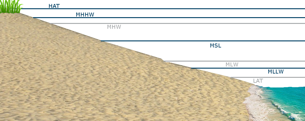
Horizontal lines in the diagram above represent "datums", or known water
levels used as baselines for measuring water depth at known locations. Mean
sea level is not constant all over the world, but instead varies at any given
location or point in time due to several factors.
Water depth listed as one
foot above "mean sea level" is really one foot above "mean sea level at
Location A". At Location B, however, the water level may be 1.5 feet above
"mean sea level". "Mean sea level" really refers to the mean water level at
that point as determined by a long-term record of tidal measurements.
Mean sea level (MSL) is not the only water level determined by long-term
tidal measurements. Highest astronomical tide (HAT), for instance, is the
highest tide ever seen in the measurement record at a given point. It
indicates the grass line, or the level above which most structures are built.
Many other datums exist (just look at the diagram above!). Data displayed on
this site is relative to the MSL datum by default. However, the user can
change the datum to their preference. Mean lower-lower water (MLLW) is a
popular choice as it indicates the average of all daily lowest tide
measurements. In a way it shows the average lowest tide, and so is a
conservative baseline against which to compare possible flooding levels.
Mean higher-high water (MHHW) has a similar meaning to MLLW, except it is the
average of all daily highest tide measurements. The National Hurricane Center
(NHC) considers MHHW to be the "above ground" datum. In other words, any water
reaching above this datum has potential to cause flooding inland.